

Tap Tap to Zoom
Product No Longer Available
Unfortunately Garmin BlueChart g2 - Mediterranean Sea is not listed by CampSaver.You can also explore other items in the Camp & Hike, Fishing, Boating & Marine, Camping Essentials, Electronics & Power, Fishing Marine Electronics, GPS yourself to try and find the perfect replacement for you!
Product Info for Garmin BlueChart g2 - Mediterranean Sea
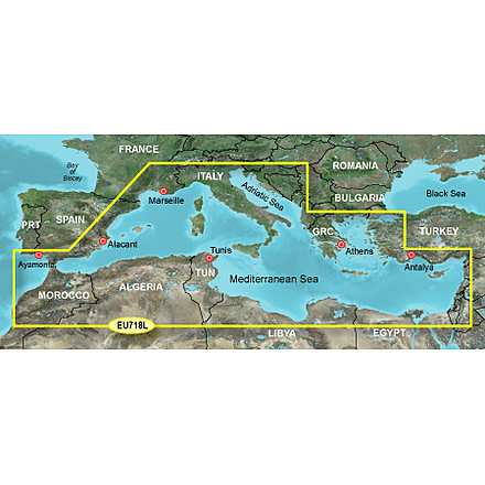
Garmin BlueChart g2 - Mediterranean Sea provides a reliable and dependable way of navigating coastlines. BlueChart g2 data from Garmin offers the ability of seeing your surroundings more clearly. Garmin Mediterranean Sea BlueChart g2 provides detailed offshore coastal coverage of the Mediterranean Sea in its entirety. Garmin BlueChart g2 enables you to receive detailed marine cartography with a convenient viewing of nautical content. Get a precise view of vessels, anchorages, obstructions, waterways, restricted areas and more. The detailed mapping capabilities on this Garmin GPS accessory includes safety shading, fishing charts, smooth data transition between zoom levels, reduction of chart discontinuities and more. We are your leading online distributor for Garmin GPS devices and GPS accessories. We also sell a full and complete line of GPS devices, portable navigational systems and GPS maps that will suit your exploration needs. For more GPS on sale from Garmin and our other brands, please visit our GPS accessories page.![]()
Specifications for Garmin Blue Chart g2 HEU718L Mediterranean Sea GPS Map:
| Formats: | microSD and GarminCard |
| Coverage: | Detailed offshore coastal coverage of the Mediterranean Sea in its entirety. Coverage features the Strait of Gibraltar, the Balearic Islands, the French Riviera, Corsica, Sardinia, Sicily, the Adriatic Sea, the Greek Islands, the Aegean Sea, the Dardanelles and Bosporus Straits, the Sea of Marmara, Cyprus, the Suez Canal, Tripoli and Algiers Harbors, and the Gulfs of Gabès and Tunisia. |
Features of Garmin BlueChart g2 Mediterranean Sea:
- Realistic navigation features showing everything from shaded depth contours and coastlines to spot soundings, navaids, port plans, wrecks, obstructions, intertidal zones, restricted areas, IALA symbols and more.
- Smooth display presentation including seamless transitioning between zoom levels and more continuity across chart boundaries.
- Safety Shading allows user to enable contour shading for all depth contours shallower than user-defined safe depth.
- Fishing charts to help scope out bottom contours and depth soundings with less visual clutter on the display.
- Choice of standard 2-D direct overhead or 3-D "over the bow" map perspective to make chart reading and orientation easier.
- Compatible with HomePort software that lets you use BlueChart data to conveniently plan and organize routes from your computer before your trip.
Package Contents:
- Garmin Blue Chart g2 Mediterranean Sea
Be the first to review this product
Garmin BlueChart g2 - Mediterranean Sea Unavailable & Discontinued Models
List of Unorderable Models
- Garmin BlueChart g2 - Mediterranean Sea microSD Card w/SD Adapter 010-C1025-20 , MPN: 010-C1025-20 , UPC: 753759096250 , Code: GA-X1-GMMDTNC-010-C1025-20
- Garmin BlueChart g2 - Mediterranean Sea GarminCard 010-C1025-10 , MPN: 010-C1025-10 , UPC: 753759096243 , Code: GA-X1-GMMDTNC-010-C1025-10