Please Enable Your Browser's Cookies Functionality
Cookies are not currently enabled in your browser, and due to this the functionality of our site will be severely restricted.
Web browser based cookies allow us to customize our site for you, save items in your cart,
and provide you with a great experience when shopping CampSaver.
Your privacy is important to us, and any personal information you supply to us is kept strictly confidential.
If you cannot enable cookies in your browser, please contact us — we are always here to help!
JavaScript is blocked by AdBlocker or ScriptBlocker
We're sorry - it looks like some elements of CampSaver are being disabled by your AdBlocker.
Unfortunately we are unable to offer our excellent shopping experience without JavaScript.
Please add "campsaver.com" and "https://csl.0ps.us/assets-e9bd785189a/" to whitelist,
or disable AdBlocker for this site (please note that we do NOT feature any annoying ads on this website).
Thanks!
Your Browser is Outdated
Unfortunately, we are unable to provide an excellent shopping experience on your browser because it lacks modern functionality needed for us
to provide a fast, secure, and enjoyable experience. If you cannot upgrade your browser or use an alternative device to visit us,
please contact us at +1-877-883-6276 and we'll be happy to assist you over the phone!
Product Info for Garmin BlueChart g3 Vision VEI510S
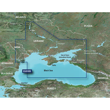
BlueChart g3 Vision VEI510S - Dnieper River & Azov SeaCoverage:Detailed coverage of the Dnieper River from the Belarus-Ukrainian border to the Black Sea the Sea of Azov and the Black Sea coast from the Danube Delta to Sochi Russia including the entire Crimean coast. Coverage includes the Kuban River to Krasnodar the Kerch Strait the Don River to Bagayevskiy and the Danube River to Braila Romania.See your vessels precise on-chart position in relation to navaids coastal
Specifications for Garmin BlueChart g3 Vision VEI510S:
Manufacturer:
Garmin
Location:
Micro SD w/ SD Adapter
Features of Garmin BlueChart g3 Vision VEI510S
Shaded depth contours coastlines spot soundings navaids port plans wrecks obstructions intertidal zones restricted areas and IALA symbols
Features up to 1-foot HD fishing contours which reveal detailed seafloor terrain
Seamless transitions between zoom levels and more continuity across chart boundaries
High resolution satellite imagery for a realistic view of the land and wate
Aerial photos of ports harbors marinas waterways navigational landmarks and other POIs
Garmin Auto Guidance technology is now capable of providing routing guidance to virtually any accessible destination on the water
Mariners Eye view 3-D perspective for a quick easy position fix
Fish Eye view 3-D perspective for an underwater view of the sea floor
Safety Shading enables contour shading for all depth contours shallower than your defined safe depths
Fishing Charts to scope out bottom contours and depth soundings with less visual clutter on the display
Plan and organize routes from your computer with HomePort
Package Contents:
Garmin BlueChart g3 Vision VEI510S
Customer Reviews for Garmin BlueChart g3 Vision VEI510S
Not Yet Reviewed
Be the first to review this product
Questions & Answers for Garmin BlueChart g3 Vision VEI510S
No Questions Asked Yet