

Tap Tap to Zoom

Code: GA-X1-BDDEAC-010-C0742-00
MPN: 010-C0742-00
UPC: 753759069223

Code: GA-X1-BDDEAC-010-C0740-00
MPN: 010-C0740-00
UPC: 753759069209

Code: GA-X1-BDDEAC-010-C0741-00
MPN: 010-C0741-00
UPC: 753759069216

Code: GA-X1-BDDEAC-010-C0739-00
MPN: 010-C0739-00
UPC: 753759069193
Product Info for Garmin On The Water GPS Cartography BlueChart g2 Vision: East Coast Large Map
The Garmin On The Water GPS Cartography BlueChart g2 Vision: East Coast Large Map sold by us is an 100% Genuine Garmin GPS Accessories product that comes with a Garmin manufacturer's warranty. Garmin On The Water GPS Cartography BlueChart g2 Vision: East Coast Large Map will fulfill all of your specific needs as Garmin products are trusted and considered to be the best GPS navigation systems all around the world. Buying a Garmin On The Water GPS Cartography BlueChart g2 Vision: East Coast Large Map from us means getting the best price and purchasing from a trusted source - we're an Authorized Garmin Dealer for all Garmin as well as running and cycling GPS, GPS, radios, and hundreds of Garmin GPS Accessories, software and maps.![]()
| Name | Description | Garmin Blue Chart g2 Vision on SD Card |
|---|---|---|
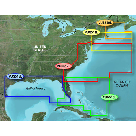
| Garmin Map - St. John - Cape Cod, Jul 08 (VUS510L) | Detailed coverage the East coast of the U.S. and Canada from Cape Cod to St. John, NB, including Boston, MA, Portsmouth, NH, and Portland, ME, as well as the Kennebec R. to Augusta, ME and the Penobscot R. to Bangor, ME. Coverage also includes Martha's Vineyard, Nantucket Island, Grand Manan Island, Mt. Desert Island, and Calais, ME as well as St. Mary's Bay and Yarmouth, NS. Bathymetric coverage includes George's Basin, Franklin Basin, and the Northeast Channel. | Garmin 010-C0739-00 |
| Garmin Map - Boston - Atlantic City, Jul 08 (VUS511L) | Detailed coverage from Gloucester, MA to Wildwood, NJ., incuding Cape Cod, Martha's Vineyard, and Nantucket Island, as well as Long Island Sound, New York Harbor, the Hudson R. to its junction with the Mowhawk R., and Raritan Bay. Bathymetric coverage of offshore features from George's Basin to Baltimore Canyon, including Bear Seamount and Hudson Canyon. | Garmin 010-C0740-00 |
| Garmin Map - Mid-Atlantic, Jul 08 (VUS512L) | Coverage of the East Coast from Barnegat Inlet, NJ through Jacksonville, FL, to Bermuda. Coverage includes the Delaware River to Trenton, NJ; the Chesepeake Bay in full; the Albemarle and Pamlico Sounds in full; Cape Fear, NC; the Savannah R. to Augusta, GA; and the St. Johns R. to Hastings, FL. Bathymetric coverage from Hudson Canyon to the Blake Escarpment, including the Wilmington Valley and Hatteras Ridge. | Garmin 010-C0741-00 |
| Garmin Map - Jacksonville - Bahamas, Jul 08 (VUS513L) | Detailed coverage of the Florida Peninsula from St. Mary's, GA through the Port of Miami to Fort Myers on the Gulf. Coverage includes the St. Johns River, Crescent Lake, Lake George, Lake Monroe, Lake Jesup, Lake Harney, Lake Okeechobee, the St. Lucie Canal, and Caloosahatchee R. in full. Detailed coverage also includes the Florida Keys, Bahamas and Turks and Caicos Islands. Bathymetric coverage of offshore features from Blake Canyon through Santaren Channel to the Torgtugas Terrace, including the Blake Escarpment and Great Bahama Bank. | Garmin 010-C0742-00 |
| Garmin BlueChart g2 Vision microSD/SD cards are compatible with the following units: | ||
| GPSMAP 525/535/545/555 | GPSMAP 420/430/440 GPSMAP 520/530/540 | |
| Limited Compatibility: | GPSMAP 4008/4010/4012 GPSMAP 4208/4210/4212 | |
| Colorado/Oregon | GPSMAP 5008/5012/5015 GPSMAP 5208/5212/5215 | |
Specifications for Garmin On The Water GPS Cartography BlueChart g2 Vision: East Coast Large Map:
| Manufacturer: | Garmin |
| Data Storage: | SD Card |
Be the first to review this product